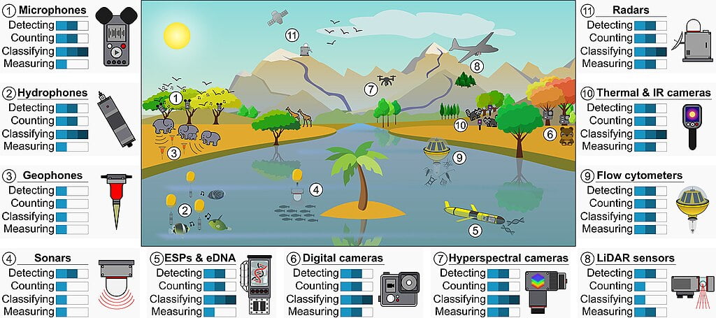
Introduction: LIDAR and Environmental Monitoring
LIDAR (Light Detection and Ranging) technology has dramatically transformed the field of environmental monitoring, offering unparalleled accuracy and efficiency in data collection. It enables researchers and scientists to map large areas, analyze diverse landscapes, and assess ecosystems’ health in previously impossible or highly time-consuming ways. The precision and scalability of LIDAR make it a cornerstone technology for understanding and managing our environment in an era where climate change and human activity pose significant challenges.
But what makes LIDAR so uniquely effective in environmental applications? Its ability to capture high-resolution 3D data over extensive areas, even in complex or inaccessible terrains, sets it apart from traditional survey methods. LIDAR doesn’t just gather surface-level information; it can penetrate vegetation cover, detect ground elevation, and provide insights into both natural and built environments. Discover how LIDAR in environmental monitoring and remote sensing technology for accurate data collection has revolutionized environmental monitoring through its applications in areas such as forestry, coastal management, hydrology, and wildlife conservation.
What is LIDAR and How Does It Work?
LIDAR is a remote sensing technology that utilizes light pulses from lasers to measure distances between the sensor and objects or surfaces. Each pulse of laser light travels to the target, reflects off it, and returns to the sensor. The system calculates the distance with high precision by measuring the time it takes for the pulse to return (known as the time of flight). This data is used to generate 3D models and detailed maps of the environment, offering insights that go far beyond simple aerial photography or satellite imagery.
Key Components of a LIDAR System:
- Laser: The laser is the source of the emitted pulses. Depending on the application, it can operate in the ultraviolet, visible, or infrared spectrum. For environmental purposes, infrared lasers are often used as they can penetrate dense vegetation.
- Scanner and Optics: The scanner directs the laser pulses across the landscape, determining the direction and pattern of the scan. Some systems use rotating mirrors to scatter the beams across a wide area, ensuring comprehensive coverage of the target region.
- Receiver: After the laser pulses hit the surface, the reflected light returns to the receiver. The receiver collects and processes this data, capturing billions of points during a single flight over the area. Each data point represents the distance between the sensor and an object (such as trees, buildings, or the ground).
- GPS and Inertial Measurement Unit (IMU): Accurate mapping requires precise knowledge of the LIDAR system’s location and orientation. The GPS tracks the system’s position, while the IMU accounts for any movements or tilts during data collection. This ensures geospatial accuracy, which is essential for environmental monitoring.
These components work in unison to create detailed “point clouds” — dense sets of data points that represent the 3D shape of the environment. These point clouds are then processed to form high-resolution maps, models, and visualizations used in environmental analysis.
LIDAR in Environmental Monitoring
Forest Canopy and Biomass Assessment
Forests play a critical role in global carbon cycles, acting as major carbon sinks. Monitoring forest health, structure, and biomass is essential for assessing their contribution to carbon sequestration and understanding deforestation’s impact on climate change. LIDAR mappers provide a precise method for examining forest canopies, measuring tree height, and crown width, and even estimating biomass through 3D canopy mapping.
LIDAR can capture data on both individual trees and the overall forest structure. This data is crucial for biodiversity studies, as the height and density of forest canopies often indicate the richness of species in the ecosystem. Traditional methods, such as ground surveys, are labor-intensive and limited by accessibility challenges, but LIDAR’s airborne capabilities overcome these barriers, allowing researchers to cover extensive areas, even in remote or densely vegetated regions.
Coastal and Erosion Monitoring
Coastal regions are some of the most vulnerable ecosystems due to sea-level rise, coastal erosion, and extreme weather events. Understanding the changing dynamics of shorelines is critical for coastal management and mitigation strategies against natural disasters like floods and hurricanes. LIDAR’s high-resolution mapping of coastal zones allows for precise monitoring of shoreline changes, sand dunes, and erosion patterns.
LIDAR is particularly useful in studying sediment transport, which plays a significant role in beach nourishment and coastal defense. By regularly scanning coastal regions, LIDAR can detect subtle shifts in the landscape, enabling early warning systems for coastal erosion. This is invaluable for coastal cities and communities that need to prepare for rising sea levels and increased storm surges due to climate change.

Floodplain Mapping and Hydrology
Floodplain mapping is essential for understanding water flow, flood risks, and watershed management. Accurate topographical data from LIDAR can reveal subtle elevation changes in floodplains that may influence water flow during heavy rainfall or river flooding. LIDAR’s ability to map both vegetation and ground elevation simultaneously helps hydrologists model flood patterns more accurately than traditional methods.
In addition, LIDAR-generated Digital Elevation Models (DEMs) are critical for creating flood simulations. These models can predict areas at risk of flooding, allowing planners to implement flood prevention measures, such as levee construction or land-use changes, and optimize disaster response strategies. By combining LIDAR data with hydrological models, authorities can reduce the risk of flood-related disasters, protect vulnerable communities, and manage water resources more effectively.
Wildlife Habitat Analysis
Conservation efforts depend on a clear understanding of wildlife habitats and the impact of environmental changes on biodiversity. LIDAR provides detailed information about the structure of vegetation, the topography of the landscape, and other environmental variables that influence wildlife habitats.
One of the major advantages of LIDAR is its ability to penetrate forest canopies and measure the understory, a critical habitat for many wildlife species. It can track habitat changes over time, such as deforestation or urban expansion, and provide data for habitat suitability models. These models help conservationists assess which areas are most important for species preservation and where human intervention (such as habitat restoration) is needed.
LIDAR also allows for more accurate tracking of ecosystem changes due to climate change, offering a better understanding of how shifts in temperature and weather patterns are impacting wildlife and their habitats.
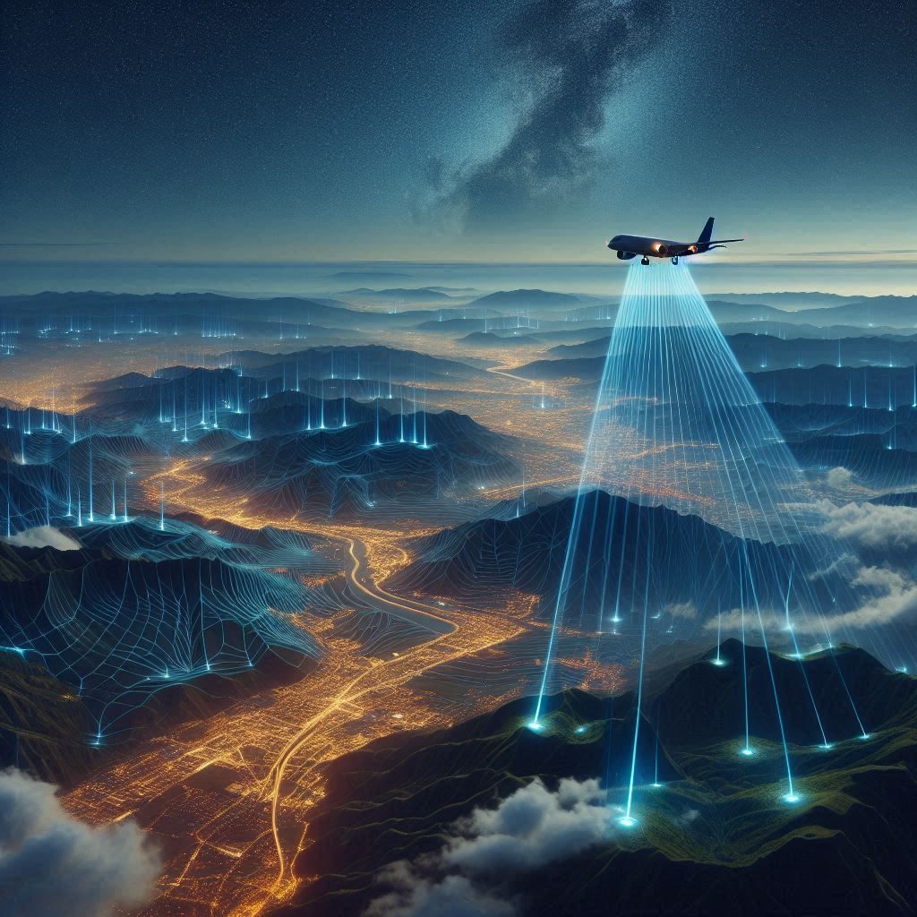
Remote Sensing LIDAR: Advancing Earth Observation
Remote sensing is the practice of collecting data from a distance, typically from satellites, planes, or drones. LIDAR stands out in the field of remote sensing because it provides active illumination, meaning it emits its own laser pulses rather than relying on natural sunlight or passive sensors. This allows LIDAR to operate effectively in low-light or cloudy conditions, where traditional optical remote sensing methods may fail.
LIDAR’s high spatial resolution and precision make it the go-to technology for many environmental applications, from tracking vegetation growth to assessing geological formations. Whether used in agriculture, forestry, urban planning, or disaster management, LIDAR plays a crucial role in advancing Earth observation.
Benefits of Remote Sensing LIDAR:
- All-weather capability: LIDAR is less affected by weather conditions, such as cloud cover, than optical remote sensing technologies.
- High spatial resolution: The point clouds generated by LIDAR provide much higher spatial resolution than traditional imaging systems.
- Precision mapping: LIDAR can capture intricate details of topographical features, making it ideal for environmental monitoring.
Drones with LIDAR: A New Frontier in Environmental Monitoring
Integrating LIDAR systems with drones has opened a new chapter in environmental monitoring. Drones equipped with LIDAR technology provide unparalleled advantages in data collection, especially in remote or hard-to-reach areas that are inaccessible to traditional manned aircraft or ground-based systems. The combination of the mobility of drones and the precision of LIDAR allows environmental researchers to collect high-resolution data more efficiently, affordably, and with greater accuracy.
Traditional environmental monitoring often requires expensive and time-consuming methods, such as ground-based surveys or the use of helicopters and planes. Drones with LIDAR systems now offer a faster and more cost-effective solution, reducing the need for extensive manned operations while providing real-time, high-quality data. The versatility of drones also allows for continuous monitoring in challenging environments such as dense forests, mountainous regions, or coastal areas.

Key Advantages of Using Drones with LIDAR:
- Flexibility and Mobility: Drones are capable of flying at low altitudes and navigating complex terrains such as dense forests, rugged mountains, or narrow valleys. Unlike traditional LIDAR systems mounted on planes or satellites, drones can perform surveys at much closer proximity to the ground, which enhances the accuracy of data collection. The ability to hover and change direction mid-flight makes drones highly adaptable to changing environmental conditions.
- Cost-Effective: Drones equipped with LIDAR significantly reduce operational costs compared to traditional manned aircraft. Helicopters or planes require substantial fuel, manpower, and maintenance, all of which drive up the cost of large-scale environmental surveys. Drones, on the other hand, are less expensive to operate, maintain, and deploy, making them an attractive option for both small-scale and large-scale environmental monitoring projects. This cost efficiency allows for more frequent data collection, ensuring up-to-date environmental assessments.
- Speed and Accuracy: Drones with LIDAR technology can quickly cover large areas, collecting billions of data points in a single flight. This real-time data collection enables faster decision-making, whether for forest management, disaster response, or land-use planning. Drones can provide immediate insights, allowing researchers to identify environmental changes, such as deforestation or erosion, almost instantly. Furthermore, LIDAR’s precision ensures that even the smallest topographical changes are detected, leading to more accurate assessments.
Applications of Drones with LIDAR
The combination of LIDAR technology and drone mobility has expanded the range of applications in environmental monitoring, providing new opportunities for environmental research and conservation efforts.
- Forest Management:
Drones equipped with LIDAR are revolutionizing forestry management by providing detailed data on tree height, canopy density, and biomass. This technology is crucial for monitoring deforestation, assessing forest health, and tracking reforestation efforts. LIDAR drones can cover vast forest areas in a short time, offering insights that ground-based surveys cannot. The ability to measure the structure of forest canopies helps researchers monitor biodiversity and carbon sequestration levels, aiding in efforts to combat climate change. - Agriculture:
LIDAR drones are increasingly being used in precision agriculture to optimize crop yields and enhance land management. By analyzing topography, field elevation, and irrigation patterns, LIDAR drones help farmers understand how water moves through their fields, identify areas of poor drainage, and assess soil health. This data enables farmers to make informed decisions about where to plant crops, how to improve water use, and when to apply fertilizers, ultimately increasing productivity while conserving resources. - Disaster Response:
LIDAR drones play a vital role in disaster response by rapidly mapping areas affected by natural disasters such as floods, landslides, or earthquakes. In the aftermath of a disaster, drones can quickly survey the area, generating detailed 3D maps that show the extent of the damage. This data is critical for emergency response teams as they plan recovery efforts and allocate resources. For example, after a flood, LIDAR drones can assess which areas are still underwater, where roads have been washed away, and where infrastructure has been damaged. - Coastal Erosion Monitoring:
Coastal regions are highly susceptible to erosion caused by rising sea levels, storms, and human activities. LIDAR drones can track changes in shorelines over time, providing valuable data on sediment movement, beach erosion, and the impact of storm surges. The ability to generate high-resolution 3D models of coastal areas helps in the development of strategies to mitigate the impact of coastal erosion and protect vulnerable ecosystems and communities.
LIDAR Mappers: Transforming Data into Actionable Insights
Collecting data through LIDAR systems is only the first step. The vast amounts of raw data generated by LIDAR drones need to be processed, analyzed and transformed into actionable insights. This is where LIDAR mappers come into play. LIDAR mappers are specialized software platforms designed to process the billions of data points collected by LIDAR systems and convert them into usable maps, 3D models, and other analytical tools.
Key Features of LIDAR Mappers:
- Data Processing and Filtering:
LIDAR mappers allow users to filter, classify, and clean up raw LIDAR data to remove noise and irrelevant points. This helps in refining the data and focusing on specific features, such as ground elevation, vegetation, or built structures. - 3D Visualization:
One of the main benefits of LIDAR mappers is their ability to generate 3D models of the terrain or environment. These 3D visualizations provide a more comprehensive view of the area being studied, enabling researchers and planners to make better-informed decisions. Whether used for urban planning, forestry management, or flood risk analysis, these visual tools are critical for understanding complex landscapes. - Integration with GIS:
Many LIDAR mappers integrate seamlessly with Geographic Information Systems (GIS), allowing users to overlay LIDAR data with other geographic information, such as satellite imagery, topographic maps, and demographic data. This integration enhances the analysis and provides a broader context for environmental monitoring.
Popular LIDAR Mapper Tools:
- ArcGIS LIDAR:
ArcGIS is a widely used GIS platform that includes robust tools for processing LIDAR data. ArcGIS LIDAR is particularly known for its ability to perform terrain analysis, vegetation mapping, and 3D modeling, making it a popular choice for environmental monitoring. - Global Mapper:
Global Mapper is another versatile tool that offers a wide range of LIDAR processing capabilities. Known for its user-friendly interface, Global Mapper is widely used in both environmental and engineering applications, including land use planning and disaster management. - LAStools:
LAStools is a highly efficient software toolset designed for rapid processing of large LIDAR datasets. Its speed and accuracy make it an essential tool for anyone dealing with large-scale environmental surveys or complex data analysis.
Conclusion: The Future of LIDAR in Environmental Monitoring
LIDAR technology, especially when combined with drone capabilities, is transforming the field of environmental monitoring. The precision, scalability, and cost-efficiency of LIDAR drones make them indispensable tools for addressing today’s environmental challenges, from deforestation to coastal erosion and disaster recovery. As the technology continues to evolve and become more affordable, LIDAR is set to play an even more critical role in environmental conservation and management efforts.
By combining LIDAR with cutting-edge remote sensing techniques, environmental monitoring is poised to enter a new era of accuracy, efficiency, and innovation. Whether it’s assessing forest health, monitoring flood risks, or planning for climate change adaptation, LIDAR drones and mappers are at the forefront of this transformation, offering solutions that can make a real difference in preserving the planet for future generations.
Explore below other interesting blogs: